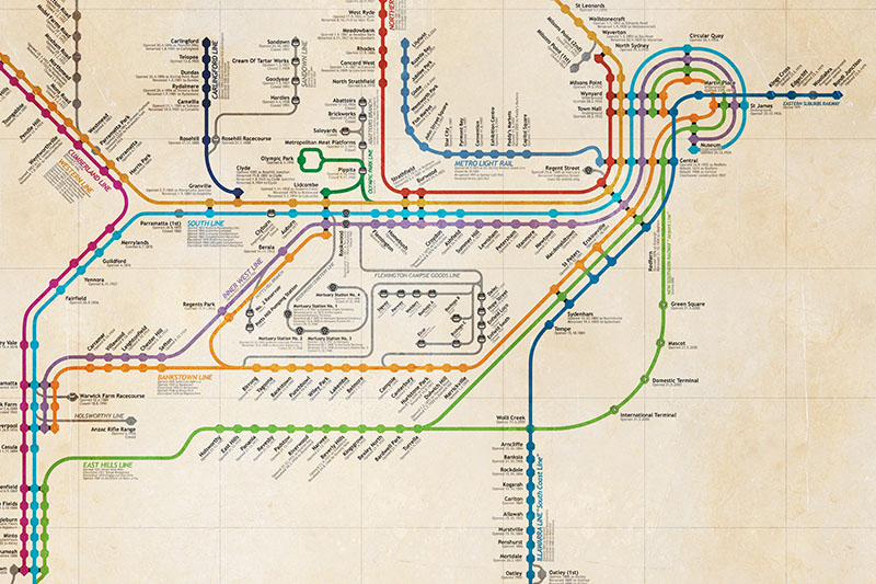
Map of the history of Sydney's railways
This is a project that I started -- and kind of abandoned -- several years ago. The story is this: Once, during a trip to Melbourne, I picked up a cool poster showing the entire railway network of the city, complete with all of the stations and lines that had closed down over the years. I quite liked it. I decided to make one for Sydney. I stupidly underestimated the magnitude of this task.
So, I edited it, on-again-off-again, until I ended up with the final version, which I display here. Is it 100% accurate? Probably not. Is it educational? Undoubtedly. Should you always do further research when presented with information on the internet? Of course you should.
Thanks to all the folks at railpage.com.au's forums who helped all those years ago, without your assistance, I would never have had the impetus to continue with this thing. Thanks also to nswrail.net for being such a ludicrously awesome resource for New South Wales railway history, and a fantastic tool for clarifying a lot of the details that went into this map.
If you find any glaring errors, by all means, let me know. I probably won't make any changes, though, because this project has very much been and gone, and it's a huge undertaking to edit it.
Click here for the full, high-res (but heavily compressed) version if you want to read the text. (Warning: is gigantic, won't work in full-resolution on an iPad or iPhone without special software.)